What is a Topographic Map?
A topographic map is a type of map that shows the physical features of an area, including its hills, valleys, plains, and bodies of water. But what makes these maps special is their ability to show elevation, or height above sea level, which they do through something called contour lines.
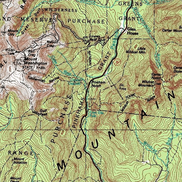
Understanding Contour Lines
Contour lines are the heart of a topographic map. Each line represents a specific elevation, and when you put them together, they create a detailed picture of the terrain. Here’s what you need to know about contour lines:
- Close Together vs. Far Apart: When contour lines are close together, it means the slope is steep. When they’re far apart, it indicates a gentle slope.
- Closed Loops: These often represent hills or mountains. The smallest loop is the highest point.
- V-Shaped Lines: These usually indicate valleys or rivers. The point of the “V” typically points uphill.
Symbols and Colors on a Topographic Map
Topographic maps use various symbols and colors to represent different features:
- Blue: Water features like lakes, rivers, and streams.
- Green: Vegetation such as forests.
- Black: Man-made features like buildings and roads.
- Red: Major highways and boundaries.
- Brown: Contour lines.
Why are Topographic Maps Important?
Topographic maps are crucial in many fields:
- Geology: Geologists use topographic maps to understand the structure of Earth’s surface.
- Hiking and Camping: Outdoor enthusiasts use these maps to plan routes and navigate terrain.
- Urban Planning: City planners use topographic maps when designing infrastructure, like roads and buildings.
Understanding how to read a topographic map is a valuable skill that can help you appreciate the complexity of our planet’s landscape.